Dispatch 04 – Life at sea without email
Lat: 46°N
Long: 160°E
Air temp: 12.36°C, 54.2°F
Sea temp: 11.284°C, 52°F
Sky: mostly cloudy and very foggy
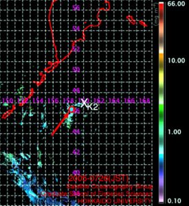
The red arrow points to circle on this map where R/V Revelle was positioned when this satellite image of ocean color was taken on July 26th. The position of the Japanese time series site K2 is noted by the X in the middle of the figure.
The red arrow points to circle on this map where R/V Revelle was positioned when this satellite image of ocean color was taken on July 26th. The position of the Japanese time series site K2 is noted by the X in the middle of the figure.
Not long ago, communications with research vessels between scientists and home were difficult, slow and/or expensive. Often there were simple radio transmissions to shore- “Hi honey, how are the kids, OVER”, or poor quality satellite phone connections that might set you back $50 or more per call. Now, most US scientific research vessels have some sort of email connection, maybe not continuous and maybe not for free use, but available none the less to write a quick note to someone back home.
This transition to email also means that going to sea has changed from being a time that is focused on the research at hand alone, to one where the office can catch up to you, no matter where you are working. Science manuscripts and even research proposals have been sent in from the high seas by busy scientists, who are now forever linked to the home base.
This is my first experience on a research ship with continuous access to the internet (vs. only email being sent on/off several times a day). While it is slow (much like a land line on phone), it was convenient for me to be able to find sites directly with satellite images of ocean properties, just by clicking away on my computer, or for locating on line manuals to repair equipment.
There still are glitches of course in communications, as when our email went down for three days due to a problem on shore. This happened right as we are busy seeking out the best site to conduct our experiments. One important piece of information in our search is satellite born sensors of ocean color (in our case, surface ocean chlorophyll which is an indicator of plant biomass) and temperature. Without our internet link, we could not receive satellite images that are being made available to us thanks to the efforts of Hidetada Kiyofuji and colleagues at Hokkaido University in the lab of Dr. Sei-ichi Saito, and by VERTIGO scientist Dr. David Siegel and his student Toby Westberry at University of California, Santa Barbara.
We have yet to complete our initial site survey, but after these anxious days without email contact, the first images arrived. Unfortunately, most of the image is black due to clouds that are common in this region and prohibit the satellite from viewing this part of the ocean. The few areas in blue including our one sunny little moment so far at sea on the R/V Revelle, indicate surface ocean chlorophyll levels of less than one milligram per cubic meter. Our underway sensors on the ship have seen chlorophyll levels significantly higher, but these are obscured by the clouds in this image. VERTIGO scientists will be using underway data and satellite images (hopefully with fewer clouds in the way!) to choose a site where on July 30th most of the free vehicles and drifting particle collectors will be launched.
Tomorrow we reach the end of our survey and choose a location to start putting our particle collectors in the water. All sampling systems are ready to go. Typhoon Banyon has weakened considerably, but will likely reach us tonight with 35 knot winds- enough to keep us from collecting any more samples, but fortunately lasting here for less than one day. Who knows, the storm may just blow away those clouds and allow us a high altitude view of K2 and just enough new mixing to really set VERTIGO off on a great start, with a clear view and high particle flux conditions that we have been searching for.
— Ken Buesseler